Prozor-Rama
Prozor-Rama
Općina Prozor-Rama (Serbo-Croatian) | |
|---|---|
Town and municipality | |
 Panoramic view | |
 Flag  Seal | |
 Location of Prozor-Rama within Bosnia and Herzegovina. | |
 Prozor-Rama | |
| Coordinates: 43°49′12″N 17°36′36″E / 43.82000°N 17.61000°E | |
| Country | |
| Entity | Federation of Bosnia and Herzegovina |
| Canton | |
| Geographical region | Herzegovina |
| Government | |
| • Municipal mayor | Jozo Ivančević (RNP) |
| Area | |
• Town and municipality | 477 km2 (184 sq mi) |
| Population (2013 census) | |
• Town and municipality | 14,280 |
| • Density | 34/km2 (88/sq mi) |
| • Urban | 3,367 |
| Time zone | UTC+1 (CET) |
| • Summer (DST) | UTC+2 (CEST) |
| Area code | +387 36 |
| Website | www |
Prozor-Rama (Serbian Cyrillic: Прозор-Рама) is a municipality located in Herzegovina-Neretva Canton of the Federation of Bosnia and Herzegovina, an entity of Bosnia and Herzegovina. Its seat is Prozor. Also, Ramsko lake is located in the municipality.
History
In the Middle Ages, the King of Hungary held the title of King of Rama named after this region.
When the German and Italian Zones of Influence were revised on 24 June 1942, Prozor fell in Zone III, administered civilly by Croatia and militarily by Croatia and Germany.[1]
-
 Seferov-Han in the Rama valley, 1897
 -
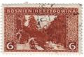 Rama valley on 1906 Austro-Hungarian stamp
 -
 Italians and Chetniks in Prozor in 1943 ("Operation Alfa")
 -
 Ustasha in Prozor, 1943
 -
 Partisans in Prozor, winter of 1942–1943
_(14758823696).jpg)


Demographics

According to the 2013 census, the population of the municipality was 14,280 and of the seat Prozor 3,367.[2]
2013
14,280 total
Settlements
Towns and settlements in the municipality are Blace, Borovnica, Dobroša Donja Vast, Donji Krančići, Donji Višnjani, Družinovići, Duge, Gmići, Gorica, Gornji Krančići, Gornji Višnjani, Gračac, Gračanica, Grevići, Heljdovi, Here, Hudutsko, Ivanci, Jaklići, Klek, Kovačevo Polje, Kozo, Kućani, Kute, Lapsunj, Lizoperci, Ljubunci, Lug, Maglice, Meopotočje, Mluša, Ometala, Orašac, Pajići, Parcani, Paroš, Ploča, Podbor, Proslap, Prozor, Ravnica, Ripci, Rumboci, Šćipe, Šćit, Šerovina, Skrobućani, Šlimac, Tošćanica, Trišćani, Ustirama, Uzdol, Varvara and Zahum.[3]
Sports
The area is home to the football club HNK Rama, and basketball club HKK Rama.
Notable people
References
- ^ Trgo 1964, p. 341.
- ^ "Naseljena Mjesta 1991/2013" (in Bosnian). Statistical Office of Bosnia and Herzegovina. Retrieved October 17, 2021.
- ^ "Naseljena Mjesta 1991/2013" (in Bosnian). Statistical Office of Bosnia and Herzegovina. Retrieved October 17, 2021.
Bibliography
- Trgo, Fabijan, ed. (1964). Zbornik dokumenata i podataka o Narodno-oslobodilačkom ratu Jugoslovenskih naroda. Vol. V, 32.
External links
 Media related to Prozor-Rama Municipality at Wikimedia Commons
- Official website of municipality Prozor - Rama
- Ramski Vjesnik - local news portal
- rama-prozor.info
- prozor-x.com
Municipalities of the Herzegovina-Neretva Canton | ||
|---|---|---|

| International | |
|---|---|
| National | |
| Other | |
This Herzegovina-Neretva Canton geography article is a stub. You can help Wikipedia by adding missing information. |
Content Disclaimer
Informasi ini disarikan dari Wikipedia dan disajikan kembali untuk tujuan edukasi. Konten tersedia di bawah lisensi CC BY-SA 3.0. Kami tidak bertanggung jawab atas ketidakakuratan data yang bersumber dari kontribusi publik tersebut.
- The information displayed on this website is sourced in part or in whole from Wikipedia and has been adapted for the purpose of restating it. We strive to provide accurate and relevant information, however:
- There is no guarantee of absolute accuracy. Wikipedia is an open, collaborative project that can be edited by anyone, so information is subject to change.
- It is not intended to constitute professional advice. The content displayed is for informational and educational purposes only. For important decisions (e.g., medical, legal, or financial), please consult a professional.
- Content copyright. Wikipedia is licensed under the Creative Commons Attribution-ShareAlike License (CC BY-SA). This means that content may be reused with appropriate attribution and shared under a similar license.
- Responsible use. Any risk arising from the use of information from this website is entirely the responsibility of the user.