Paythorne
| Paythorne | |
|---|---|
 Paythorne Methodist Chapel | |
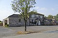
 Paythorne Shown within Ribble Valley  Paythorne Location within Lancashire | |
| Population | 95 (2001 Census)[1] |
| OS grid reference | SD829519 |
| Civil parish |
|
| District | |
| Shire county | |
| Region | |
| Country | England |
| Sovereign state | United Kingdom |
| Post town | CLITHEROE |
| Postcode district | BB7 |
| Dialling code | 01200 |
| Police | Lancashire |
| Fire | Lancashire |
| Ambulance | North West |
| UK Parliament | |
Paythorne is a small village and civil parish in Ribble Valley, Lancashire, England. It is situated alongside the River Ribble, north-east of Clitheroe, and on the boundary with North Yorkshire. Other parishes adjacent to Paythorne are Halton West, Nappa (both in North Yorkshire), Newsholme, Horton, Gisburn, Sawley, Bolton-by-Bowland and Gisburn Forest (all in Lancashire).[2] The nearest town is Barnoldswick, situated 7 kilometres (4.3 mi) south-east of the village.[3] Paythorne is on the edge of the Forest of Bowland Area of Outstanding Natural Beauty, although only a small area in the west of the parish is within the area's boundary.[2] The Ribble Way long-distance walk passes through the village.[4]
Paythorne is a small village, with not many facilities although it has a pub (the Buck Inn) and a Methodist chapel. A mobile post office serves Gisburn; the nearest permanent Post Office is at Hellifield, 5 miles away. The area surrounding the village consists of several farms, and moorland including Paythorne Moor north of the village.
The meaning of the place name is uncertain, however suggestions have included "a thorn bush beside a pathway" and "a peacock shaped thorn bush".[5]
The manors of Paythorne and Ellenthorpe were part of the Percy Fee which was listed under Craven in the Domesday Book.[6] In the 1140s, William de Percy II, feudal baron of Topcliffe, granted Ellenthorpe, in the southwest of the civil parish, to the Cistercian monks who founded Sawley Abbey.[7] The monks developed a grange here.[8]
Historically, Paythorne was in the West Riding of Yorkshire, and before it became a parish, it was a township in the parish of Gisburn.[9]
In the 2001 census, Paythorne had a population of 95,[1] however in 2011 the parish was grouped with Newsholme and Horton (2001 pop. 50 and 76), giving a total of 253.[10][2] From the 2011 Census population details had been included in Newsholme parish.
For local government, Paythorne is part of the ward of Gisburn, Rimington in the borough of Ribble Valley.[11]
The Pennine Bridleway National Trail and Ribble Way pass through the parish, crossing the Ribble on the Paythorne Bridge. [12][13]
Media gallery
-
 The Buck Inn
 -
 Paythorne Moor
 -
 Paythorne Bridge over the River Ribble
 -
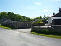 Ellenthorpe Farm in southwest of the parish (Thorp)
 -
 Carters Farmhouse
.jpg)


.jpg)

See also
References
- ^ a b "Parish headcount" (PDF). Lancashire Parish Portal. Lancashire County Council. Archived from the original (PDF) on 10 December 2006. Retrieved 13 December 2008.
- ^ a b c "Wards and parishes map". MARIO. Lancashire County Council. Retrieved 1 March 2018.
- ^ "OpenStreetMap". Retrieved 13 December 2008.
- ^ Alan Shepley; Graham Wilkinson (2005). Walking the Ribble Way – A guide from sea to source. Wood Education Programme Trust. ISBN 978-0-9541809-1-1. OCLC 124023932.
- ^ "Parish Council Details: Paythorne Parish Council". Lancashire Parish Portal. Lancashire County Council. Archived from the original on 27 June 2009. Retrieved 13 December 2008.
- ^ Whitaker, Thomas Dunham (1878), The history and antiquities of the deanery of Craven 3rd ed. (PDF), Dodson (Leeds) and Cassell, Petter & Galpin (London), pp. 44, 51–52, OCLC 504073084, retrieved 30 May 2024
- ^ John Harland, ed. (1853). Historical account of the Cistercian Abbey of Salley. J Russell Smith, London. p. 7. Retrieved 30 May 2024.
- ^ Charles Travis Clay; William Farrer, eds. (2013). Early Yorkshire Charters: Volume 11, The Percy Fee. Cambridge University Press. p. 232.
- ^ "Paythorne Tn/CP Yorkshire through time – Descriptive Gazetteer entries". A Vision of Britain through Time. University of Portsmouth & others. 2008. Retrieved 14 December 2008.
- ^ UK Census (2011). "Local Area Report – Newsholme Parish (1170215119)". Nomis. Office for National Statistics. Retrieved 1 March 2018.
- ^ The Borough of Ribble Valley (Electoral Changes) Order 2001. Office of Public Sector Information. 13 July 2001. ISBN 0-11-029681-8. Retrieved 13 December 2008.
- ^ MKH Computer Services Ltd. "Pennine Bridleway — LDWA Long Distance Paths". Ldwa.org.uk. Retrieved 7 April 2016.
- ^ MKH Computer Services Ltd. "Ribble Way — LDWA Long Distance Paths". Ldwa.org.uk. Retrieved 7 April 2016.
This Lancashire location article is a stub. You can help Wikipedia by adding missing information. |
Content Disclaimer
Informasi ini disarikan dari Wikipedia dan disajikan kembali untuk tujuan edukasi. Konten tersedia di bawah lisensi CC BY-SA 3.0. Kami tidak bertanggung jawab atas ketidakakuratan data yang bersumber dari kontribusi publik tersebut.
- The information displayed on this website is sourced in part or in whole from Wikipedia and has been adapted for the purpose of restating it. We strive to provide accurate and relevant information, however:
- There is no guarantee of absolute accuracy. Wikipedia is an open, collaborative project that can be edited by anyone, so information is subject to change.
- It is not intended to constitute professional advice. The content displayed is for informational and educational purposes only. For important decisions (e.g., medical, legal, or financial), please consult a professional.
- Content copyright. Wikipedia is licensed under the Creative Commons Attribution-ShareAlike License (CC BY-SA). This means that content may be reused with appropriate attribution and shared under a similar license.
- Responsible use. Any risk arising from the use of information from this website is entirely the responsibility of the user.