Moddergat
Moddergat | |
|---|---|
Village | |
 View from the seaside | |
 Flag  Coat of arms | |
| Nickname: Blabberpoepert | |
 Location in the former Dongeradeel municipality | |
 Moddergat Location in the Netherlands  Moddergat Moddergat (Netherlands) | |
| Country | |
| Province | |
| Municipality | Noardeast-Fryslân |
| Area | |
• Total | 1.91 km2 (0.74 sq mi) |
| Elevation | 1.1 m (3.6 ft) |
| Population (2021)[1] | |
• Total | 235 |
| • Density | 123/km2 (319/sq mi) |
| Time zone | UTC+1 (CET) |
| • Summer (DST) | UTC+2 (CEST) |
| Postal code | 9142[1] |
| Dialing code | 0519 |
Moddergat is a fishing village in Noardeast-Fryslân in the province of Friesland, the Netherlands. It had a population of around 221 in January 2017.[3] Before 2019, the village was part of the Dongeradeel municipality.[4]
The name of the village means 'mud hole' in Dutch and in West Frisian.[5] Moddergat is twinned with Peazens, and they are often referred to as "Peazens-Moddergat".[6][4]
In 1883, 17 of the 22 ships of Moddergat were lost at sea during a storm killing 83 fishermen. In 1958, a monument was placed on the sea dike in their honour.[7]
In 2004, NCRV television organized a competition for most beautiful place in the Netherlands. Moddergat came in second after Weerribben-Wieden National Park.[4]
History
The village was first mentioned in 1718 as Modde gat, and is supposed to mean "muddy pool".[8] The village of Peazens was founded first on the new dike along the Wadden Sea. Moddergat was founded later from Peazens, and used to consist of two hamlets: De Kamp and De Oere. The Reformed Church was built in 1912 with a wooden tower.[6]
In 1840, Moddergat was home to 220 people. Moddergat used to belong to the municipality of Westdongeradeel and Peazens to Oostdongeradeel. In 1983, the municipalities merged.[4]
Activities
Museum 't Fiskershúske consists of four fishermen's houses, the oldest of which is from 1794, and gives a display of the life and history of the fishers in Moddergat.[9]
Moddergat is one of the starting points for wadlopen (mudflat hiking). At low tide, it is possible to walk to the island of Schiermonnikoog.[10] Mudflat hiking is potentially dangerous, and is only allowed under the supervision of a licensed guide.[11]
Gallery
-
![Boethuisje [nl], place to leave the fishing nets](//upload.wikimedia.org/wikipedia/commons/thumb/6/6d/Boethuisje_De_Oere_Moddergat.jpg/120px-Boethuisje_De_Oere_Moddergat.jpg) Boethuisje, place to leave the fishing nets
Boethuisje, place to leave the fishing nets -
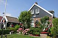 House in Moddergat
 -
 Fisher's monument
 -
 Sunset on the Wadden Sea
![Boethuisje [nl], place to leave the fishing nets](https://dosen.profillengkap.com/en/File:Boethuisje_De_Oere_Moddergat.jpg)
_-_panoramio_(10).jpg)


References
- ^ a b c "Kerncijfers wijken en buurten 2021". Central Bureau of Statistics. Retrieved 31 March 2022.
two entries
- ^ "Postcodetool for 9142DL". Actueel Hoogtebestand Nederland (in Dutch). Het Waterschapshuis. Retrieved 31 March 2022.
- ^ Aantal inwoners per woonplaats in Dongeradeel op 1 januari 2017 Archived 2017-10-21 at the Wayback Machine - Dongeradeel
- ^ a b c d "Paesens-Moddergat". Plaatsengids (in Dutch). Retrieved 31 March 2022.
- ^ "Translate Moddergat nl->en". Google. Retrieved 31 March 2022.
- ^ a b Ronald Stenvert & Sabine Broekhoven (2000). "Paesens-Moddergat" (in Dutch). Zwolle: Waanders. ISBN 90 400 9476 4. Retrieved 31 March 2022.
- ^ "Monument omgekomen zeelieden 1883, De Oere, Moddergat". Online Begraafplaatsen (in Dutch). Retrieved 31 March 2022.
- ^ "Moddergat - (geografische naam)". Etymologiebank (in Dutch). Retrieved 31 March 2022.
- ^ "t Fiskershúske". Museum.nl (in Dutch). Retrieved 31 March 2022.
- ^ "Wadlopen bij Paesens-Moddergat". Wadlopen Moddergat (in Dutch). Retrieved 31 March 2022.
- ^ "Verordening van 13 december 1995, houdende regels met betrekking tot het wadlopen (Wadloopverordening 1996)" [1996 law for mudflat hiking] (PDF). Waddenzee (in Dutch). 13 December 1995. Retrieved 31 March 2022.
External links
![]() Media related to Moddergat at Wikimedia Commons
Media related to Moddergat at Wikimedia Commons
Content Disclaimer
Informasi ini disarikan dari Wikipedia dan disajikan kembali untuk tujuan edukasi. Konten tersedia di bawah lisensi CC BY-SA 3.0. Kami tidak bertanggung jawab atas ketidakakuratan data yang bersumber dari kontribusi publik tersebut.
- The information displayed on this website is sourced in part or in whole from Wikipedia and has been adapted for the purpose of restating it. We strive to provide accurate and relevant information, however:
- There is no guarantee of absolute accuracy. Wikipedia is an open, collaborative project that can be edited by anyone, so information is subject to change.
- It is not intended to constitute professional advice. The content displayed is for informational and educational purposes only. For important decisions (e.g., medical, legal, or financial), please consult a professional.
- Content copyright. Wikipedia is licensed under the Creative Commons Attribution-ShareAlike License (CC BY-SA). This means that content may be reused with appropriate attribution and shared under a similar license.
- Responsible use. Any risk arising from the use of information from this website is entirely the responsibility of the user.