Lower Post
Lower Post is an aboriginal community in the Stikine Region[1] of far northern British Columbia, Canada, located on Highway 97, the Alaska Highway, approximately 15 miles (24 kilometres) southeast of Watson Lake, Yukon. Its historical mile designation is Mile 620. It is located near the confluence of the Dease and Liard Rivers.[2]
History
Early fur traders named it Lower Post to distinguish between the upper and lower Liard trading posts. Lower Post, or Fort Liard (its original name), had been established by an American, Rufus Sylvester, in 1872. Four years later the Hudson's Bay Company took it over and a couple of years afterwards two of its officials brokered peace between the local Kaska Dena and a raiding party of two hundred Taku.
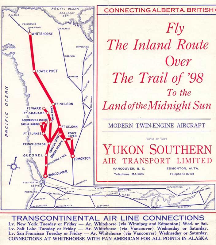
Before Lower Post became a community, it served as a fishing spot, a crossing and a meeting place. Because many different indigenous people stopped here for trading, the community still has a diverse ethnic make-up today. In the early 1940s, it served as a stopover for scheduled airline passenger service between Whitehorse and Edmonton via Fort Nelson.[3]
One of the aboriginal languages spoken in Lower Post is Kaska, of which there are very few fluent speakers.
There are no services provided at Lower Post, with residents using services at nearby Watson Lake, Yukon. Electricity is supplied by ATCO Electric Yukon as opposed to BC Hydro.[4]
The local school, Denetia School, is a K-7 elementary school that is British Columbia's most northern school and part of the School District 87 Stikine. The school currently operates as a one-room school focusing on outdoor experiential education called P.A.C.E.S. In 2011 it had a class of twelve students.[5]
In 2016, approximately 81 people lived in Lower Post, which is a decrease from the 2011 population of 105.[6]
Gallery
-
 Two men with fiddle and bow, 1945
 -
 Young woman with hat, 1945
 -
 Girl in jacket, 1945
 -
 Lower Post Young boy with horse, 1971


References
- ^ "Stikine Region". Province of British Columbia. Retrieved March 15, 2024.
The rest of the population is dispursed [sic] between the communities of Lower Post, Good Hope Lake, Jade City and Laird River [sic].
- ^ "Lower Post (community)". BC Geographical Names. Government of British Columbia – B.C. Geographical Names Office (BCGNO).
- ^ Yukon Southern Timetable, 1940.
- ^ "Yukon Electrical Company Limited and Yukon Energy Rate Schedules" (PDF). ATCO Electric Yukon. p. 7. Retrieved April 22, 2024.
- ^ "Denetia School". School District 87 Stikine. Retrieved April 22, 2024.
- ^ "Census Profile, 2016 Census, Statistics Canada - Validation Error".
59°56′N 128°30′W / 59.933°N 128.500°W
This article about a location in the Interior of British Columbia, Canada is a stub. You can help Wikipedia by adding missing information. |
Content Disclaimer
Informasi ini disarikan dari Wikipedia dan disajikan kembali untuk tujuan edukasi. Konten tersedia di bawah lisensi CC BY-SA 3.0. Kami tidak bertanggung jawab atas ketidakakuratan data yang bersumber dari kontribusi publik tersebut.
- The information displayed on this website is sourced in part or in whole from Wikipedia and has been adapted for the purpose of restating it. We strive to provide accurate and relevant information, however:
- There is no guarantee of absolute accuracy. Wikipedia is an open, collaborative project that can be edited by anyone, so information is subject to change.
- It is not intended to constitute professional advice. The content displayed is for informational and educational purposes only. For important decisions (e.g., medical, legal, or financial), please consult a professional.
- Content copyright. Wikipedia is licensed under the Creative Commons Attribution-ShareAlike License (CC BY-SA). This means that content may be reused with appropriate attribution and shared under a similar license.
- Responsible use. Any risk arising from the use of information from this website is entirely the responsibility of the user.