Indigenous mapping
Indigenous mapping is a practice where Indigenous communities own, control, access, and possess both the geographic information and mapping processes. It is based on Indigenous data sovereignty[1][2] and intellectual property.
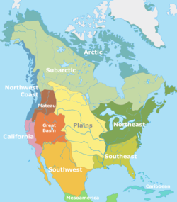
Indigenous cartographers tend to employ different strategies than colony-focused or empire-focused cartographers. Indigenous cartography may focus on stories, ever-changing landscapes,[3] and traditional knowledge.
Modern Indigenous mapping is closely association with decolonization. It can reclaim traditional land names and spaces, including sacred areas.[3]
Examples
An example of an Indigenous map is a 2.6-meter long Ojibwe scroll and story detailing the 14th-15th century emigration of the Ojibwe people. It tracks the tribe's journey their original territory in the Zhiiwitaagani-gichigami (Atlantic Ocean) to the Nayaano-nibiimaang Gichigamiin (Great Lakes). The story uses symbols, such as bird migration and a bear carrying a pack of life and coming across different lakes with his tongue, to portray geographic locations including the St. Lawrence River to Montreal, the Lachine Rapids to Mattawa, the French River to Lake Huron, through the Straits of Mackinac to Sault Ste. Marie. The scroll was created and the story was retold by Eshkwaykeeshik (James Red Sky).[4]
See also
- Indigenous land rights
- Indigenous language
- Indigenous rights
- Indigenous title
- Language revitalization
References
- ^ "Decolonizing Digital: Empowering Indigeneity Through Data Sovereignty". Animikii.
- ^ Sletto, Bjørn (1 April 2009). "Special issue: Indigenous cartographies". Cultural Geographies. 16 (2): 147–152. Bibcode:2009CuGeo..16..147S. doi:10.1177/1474474008101514. S2CID 143473978 – via SAGE Journals.
- ^ a b "Indigenous cartographers work to decolonize mapping of traditional lands". Life at OSU. 26 October 2020. Retrieved 20 April 2022.
- ^ "Red Sky's Migration Chart: Ojibwe". The Decolonial Atlas. 18 May 2015. Retrieved 20 April 2022.
| Pre-history | .svg) | ||||||||||
|---|---|---|---|---|---|---|---|---|---|---|---|
| Mythology/Religion |
| ||||||||||
| Culture |
| ||||||||||
| European colonization | |||||||||||
| Modern groups by country |
| ||||||||||
| Related topics | |||||||||||
 | ||
This cartography or mapping term article is a stub. You can help Wikipedia by adding missing information. |
Content Disclaimer
Informasi ini disarikan dari Wikipedia dan disajikan kembali untuk tujuan edukasi. Konten tersedia di bawah lisensi CC BY-SA 3.0. Kami tidak bertanggung jawab atas ketidakakuratan data yang bersumber dari kontribusi publik tersebut.
- The information displayed on this website is sourced in part or in whole from Wikipedia and has been adapted for the purpose of restating it. We strive to provide accurate and relevant information, however:
- There is no guarantee of absolute accuracy. Wikipedia is an open, collaborative project that can be edited by anyone, so information is subject to change.
- It is not intended to constitute professional advice. The content displayed is for informational and educational purposes only. For important decisions (e.g., medical, legal, or financial), please consult a professional.
- Content copyright. Wikipedia is licensed under the Creative Commons Attribution-ShareAlike License (CC BY-SA). This means that content may be reused with appropriate attribution and shared under a similar license.
- Responsible use. Any risk arising from the use of information from this website is entirely the responsibility of the user.