Hanimaadhoo
Hanimaadhoo
ހަނިމާދޫ | |
|---|---|
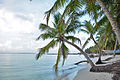
 Beach, north Hanimaadhoo | |
 Hanimaadhoo Location in Maldives | |
| Coordinates: 06°45′57″N 73°10′33″E / 6.76583°N 73.17583°E | |
| Country | Maldives |
| Geographic atoll | Thiladhummathi Atoll |
| Administrative atoll | Haa Dhaalu Atoll |
| Distance to Malé | 288.84 km (179.48 mi) |
| Dimensions | |
| • Length | 6.800 km (4.225 mi) |
| • Width | 0.730 km (0.454 mi) |
| Population (2022)[1] | |
• Total | 2,664 |
| Time zone | UTC+05:00 (MST) |
Hanimaadhoo (Dhivehi: ހަނިމާދޫ) is one of the inhabited islands of Haa Dhaalu Atoll administrative division and geographically part of Thiladhummathi Atoll in the north of the Maldives.
Geography
The island is 288.84 km (179 mi; 156 nmi) north of the country's capital, Malé.[2]
Climate
The Hanomaadhoo Meteorological Observatory is located on this island. Many flight scientific research such as those investigating aerosol concentrations in the atmosphere and the Brown Cloud phenomenon have been initiated from Hanimaadhoo.
On 27 February 2025, Hanimaadhoo recorded a temperature of 35.8 °C (96.4 °F), which is the highest temperature to have ever been recorded in the Maldives.
| Climate data for Hanimaadhoo International Airport, (elevation 1.4 m (4.6 ft), 1991−2020 normals) | |||||||||||||
|---|---|---|---|---|---|---|---|---|---|---|---|---|---|
| Month | Jan | Feb | Mar | Apr | May | Jun | Jul | Aug | Sep | Oct | Nov | Dec | Year |
| Mean daily maximum °C (°F) | 30.8 (87.4) |
31.2 (88.2) |
32.1 (89.8) |
32.6 (90.7) |
32.0 (89.6) |
31.0 (87.8) |
30.7 (87.3) |
30.6 (87.1) |
30.7 (87.3) |
30.8 (87.4) |
30.8 (87.4) |
30.7 (87.3) |
31.2 (88.2) |
| Daily mean °C (°F) | 27.9 (82.2) |
28.2 (82.8) |
29.1 (84.4) |
29.8 (85.6) |
29.5 (85.1) |
28.8 (83.8) |
28.4 (83.1) |
28.3 (82.9) |
28.3 (82.9) |
28.2 (82.8) |
28.1 (82.6) |
28.0 (82.4) |
28.6 (83.5) |
| Mean daily minimum °C (°F) | 24.5 (76.1) |
24.6 (76.3) |
25.6 (78.1) |
26.6 (79.9) |
26.5 (79.7) |
25.8 (78.4) |
25.4 (77.7) |
25.5 (77.9) |
25.4 (77.7) |
25.2 (77.4) |
24.8 (76.6) |
24.6 (76.3) |
25.4 (77.7) |
| Average precipitation mm (inches) | 38.7 (1.52) |
29.4 (1.16) |
32.7 (1.29) |
67.2 (2.65) |
234.5 (9.23) |
229.2 (9.02) |
260.5 (10.26) |
221.5 (8.72) |
174.3 (6.86) |
198.5 (7.81) |
172.4 (6.79) |
107.8 (4.24) |
1,766.7 (69.56) |
| Average precipitation days (≥ 0.1 mm) | 3.0 | 2.7 | 2.9 | 5.5 | 13.4 | 17.1 | 16.3 | 15.0 | 13.1 | 12.8 | 10.5 | 7.3 | 119.6 |
| Source: NOAA[3] | |||||||||||||
Demography
Islanders from Hathifushi and Hondaidhoo have been relocated to Hanimaadhoo in the recent years.
| Year | Pop. | ±% |
|---|---|---|
| 2006 | 1,184 | — |
| 2014 | 1,618 | +36.7% |
| 2022 | 2,664 | +64.6% |
| 2006-2014: Census populations Source: [4][1] | ||
Economy
The island is planned to be one of the developmental centres of the newly planned Mathi-Uthuru Province.
Tourism Sector
The island is slowly developing into a tourist hot spot North Of the Maldives.
Currently hanimaadhoo have several guest houses, which caters to national and international tourists.
Transport
The island is the site of Hanimaadhoo Airport, one of the few international airports of the Maldives.
Gallery
-
 Main street
 -
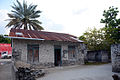 Old house made of coral bricks
 -
 West coast
 -
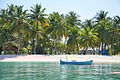 West coast
 -
 Banana plant alley, north island


References
- ^ a b "Table P5: Resident Population by island and sex, 2022" (PDF). Maldives Census. Retrieved 1 April 2025.
- ^ "Coordinate Distance Calculator". Boulter.com. Retrieved 10 August 2018.
- ^ "Hanimaadhoo Climate Normals 1991–2020". National Oceanic and Atmospheric Administration. Archived from the original on 29 February 2024. Retrieved 29 February 2024.
- ^ "Table 3.3: Total Maldivian Population by Islands" (PDF). National Bureau of Statistics. Retrieved 10 August 2018.
| Haa Alif | ||
|---|---|---|
| Haa Dhaalu | ||
| Shaviyani | ||
| Noonu | ||
| Raa | ||
| Baa | ||
| Lhaviyani | ||
| Kaafu | ||
| Alif Alif | ||
| Alif Dhaalu | ||
| Vaavu | ||
| Meemu | ||
| Faafu | ||
| Dhaalu | ||
| Thaa | ||
| Laamu | ||
| Gaafu Alifu | ||
| Gaafu Dhaalu | ||
| Gnaviyani | ||
This Maldives location article is a stub. You can help Wikipedia by adding missing information. |
Content Disclaimer
Informasi ini disarikan dari Wikipedia dan disajikan kembali untuk tujuan edukasi. Konten tersedia di bawah lisensi CC BY-SA 3.0. Kami tidak bertanggung jawab atas ketidakakuratan data yang bersumber dari kontribusi publik tersebut.
- The information displayed on this website is sourced in part or in whole from Wikipedia and has been adapted for the purpose of restating it. We strive to provide accurate and relevant information, however:
- There is no guarantee of absolute accuracy. Wikipedia is an open, collaborative project that can be edited by anyone, so information is subject to change.
- It is not intended to constitute professional advice. The content displayed is for informational and educational purposes only. For important decisions (e.g., medical, legal, or financial), please consult a professional.
- Content copyright. Wikipedia is licensed under the Creative Commons Attribution-ShareAlike License (CC BY-SA). This means that content may be reused with appropriate attribution and shared under a similar license.
- Responsible use. Any risk arising from the use of information from this website is entirely the responsibility of the user.