Friesack
Friesack | |
|---|---|
 Museum and library | |
 Coat of arms | |
Location of Friesack
within Havelland district  | |
 Location of Friesack | |
 Friesack  Friesack | |
| Coordinates: 52°44′N 12°35′E / 52.733°N 12.583°E | |
| Country | Germany |
| State | Brandenburg |
| District | Havelland |
| Municipal assoc. | Friesack |
| Subdivisions | 2 Ortsteile |
| Government | |
| • Mayor (2024–29) | Lothar Schneider[1] (SPD) |
| Area | |
• Total | 84.01 km2 (32.44 sq mi) |
| Elevation | 35 m (115 ft) |
| Population (2024-12-31)[2] | |
• Total | 2,545 |
| • Density | 30.29/km2 (78.46/sq mi) |
| Time zone | UTC+01:00 (CET) |
| • Summer (DST) | UTC+02:00 (CEST) |
| Postal codes | 14662 |
| Dialling codes | 033235 |
| Vehicle registration | HVL |
| Website | www.amt-friesack.de |
Friesack (German pronunciation: [ˈfʁiːzak] ⓘ; also Friesack/Mark) is a town in the Havelland district, in Brandenburg, in north-eastern Germany. It is situated 22 km (14 mi) northeast of Rathenow, and 25 km (16 mi) southwest of Neuruppin. It is known for its Mesolithic archaeological site.

History
During World War II, in September 1943, the Oflag 8 prisoner-of-war camp was relocated from Frauenberg to Wutzetz, present-day district of Friesack.[3] Polish, Greek, Bulgarian and Romanian officers were held in the camp before its dissolution in April 1945.[3]
Film shot in Friesack
- 1923 : Die Schlucht des Todes (The Ravine of Death) directed by Luciano Albertini and Albert-Francis Bertoni
Demography
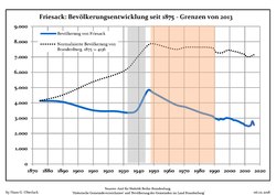
Friesack: Population development within the current boundaries (2017)[4] | ||||||||||||||||||||||||||||||||||||||||||||||||||||||||||||||||||||||||||||||||||||||||||||||||||||||||||||||||||||||||||||||||||||||
|
|
| ||||||||||||||||||||||||||||||||||||||||||||||||||||||||||||||||||||||||||||||||||||||||||||||||||||||||||||||||||||||||||||||||||||
Sons and daughters of the town

- Emil Schallopp (1843-1919), chess master and writer
- Karsten Wettberg (born 1941), football coach
- Adalbert von Bredow (1814-1890), Prussian general
References
- ^ Landkreis Havelland Wahl der Bürgermeisterin / des Bürgermeisters. Retrieved 10 July 2024.
- ^ "Bevölkerungsstand im Land Brandenburg Dezember 2024 (Fortgeschriebene amtliche Einwohnerzahlen, basierend auf dem Zensus 2023)" (XLS). Amt für Statistik Berlin-Brandenburg (in German).
- ^ a b Megargee, Geoffrey P.; Overmans, Rüdiger; Vogt, Wolfgang (2022). The United States Holocaust Memorial Museum Encyclopedia of Camps and Ghettos 1933–1945. Volume IV. Indiana University Press, United States Holocaust Memorial Museum. pp. 211–212. ISBN 978-0-253-06089-1.
- ^ Detailed data sources are to be found in the Wikimedia Commons.Population Projection Brandenburg at Wikimedia Commons
Towns and municipalities in Havelland | ||
|---|---|---|
 | ||
| International | |
|---|---|
| Geographic | |
This Brandenburg location article is a stub. You can help Wikipedia by adding missing information. |
Content Disclaimer
Informasi ini disarikan dari Wikipedia dan disajikan kembali untuk tujuan edukasi. Konten tersedia di bawah lisensi CC BY-SA 3.0. Kami tidak bertanggung jawab atas ketidakakuratan data yang bersumber dari kontribusi publik tersebut.
- The information displayed on this website is sourced in part or in whole from Wikipedia and has been adapted for the purpose of restating it. We strive to provide accurate and relevant information, however:
- There is no guarantee of absolute accuracy. Wikipedia is an open, collaborative project that can be edited by anyone, so information is subject to change.
- It is not intended to constitute professional advice. The content displayed is for informational and educational purposes only. For important decisions (e.g., medical, legal, or financial), please consult a professional.
- Content copyright. Wikipedia is licensed under the Creative Commons Attribution-ShareAlike License (CC BY-SA). This means that content may be reused with appropriate attribution and shared under a similar license.
- Responsible use. Any risk arising from the use of information from this website is entirely the responsibility of the user.