Cutler Stack
 | |
| Geography | |
|---|---|
| Location | Antarctica |
| Coordinates | 62°36′44.5″S 60°58′51.5″W / 62.612361°S 60.980972°W |
| Archipelago | South Shetland Islands |
| Length | 0.17 km (0.106 mi) |
| Width | 0.15 km (0.093 mi) |
| Highest elevation | 16 m (52 ft) |
| Administration | |
| Administered under the Antarctic Treaty System | |
| Demographics | |
| Population | uninhabited |

Cutler Stack is a conspicuous sea stack extending 170 by 150 m (186 by 164 yd) and rising to 16 m (52 ft), lying off Ivanov Beach in the south of Barclay Bay, western Livingston Island in the South Shetland Islands, Antarctica. The area was visited by early 19th century sealers.
The feature is named after Captain Benjamin Cutler, part owner of the American brig Frederick that visited the area in 1820–21, and Master of the sealing schooner Free Gift that visited the area in 1821–22; his name was found carved on a piece of whale vertebra excavated from a stone hut on Byers Peninsula by a FIDS survey party in 1957–58.
Location
The stack is located at 62°36′44.5″S 60°58′51.5″W / 62.612361°S 60.980972°W which is 300 m (328 yd) north-northwest of Nedelya Point, 2.8 km (1.7 mi) east-northeast of Lair Point and 4.72 km (2.93 mi) southwest of Rowe Point (British mapping in 1968, detailed Spanish mapping in 1992, and Bulgarian mapping in 2009 and 2017).
See also
- Composite Antarctic Gazetteer
- List of Antarctic islands south of 60° S
- SCAR
- Territorial claims in Antarctica
Maps
- Península Byers, Isla Livingston. Mapa topográfico a escala 1:25000. Madrid: Servicio Geográfico del Ejército, 1992. (Map image on p. 55 of the linked study)
- L.L. Ivanov. Antarctica: Livingston Island and Greenwich, Robert, Snow and Smith Islands. Scale 1:120000 topographic map. Troyan: Manfred Wörner Foundation, 2009. ISBN 978-954-92032-6-4
Gallery
-
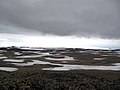 Eastern Byers Peninsula in Livingston Island with left to right Lair Hill, Robbery Beaches, Sparadok Point, Tsamblak Hill and Negro Hill in the middle ground; and Rowe Point, Cutler Stack, Ivanov Beach, Nedelya Point, Urvich Wall surmounted by the slopes of Rotch Dome, and Clark Nunatak in the background
 -
 Topographic map of Livingston Island, Greenwich, Robert, Snow and Smith Islands


Notes
References


This Livingston Island location article is a stub. You can help Wikipedia by adding missing information. |
Content Disclaimer
Informasi ini disarikan dari Wikipedia dan disajikan kembali untuk tujuan edukasi. Konten tersedia di bawah lisensi CC BY-SA 3.0. Kami tidak bertanggung jawab atas ketidakakuratan data yang bersumber dari kontribusi publik tersebut.
- The information displayed on this website is sourced in part or in whole from Wikipedia and has been adapted for the purpose of restating it. We strive to provide accurate and relevant information, however:
- There is no guarantee of absolute accuracy. Wikipedia is an open, collaborative project that can be edited by anyone, so information is subject to change.
- It is not intended to constitute professional advice. The content displayed is for informational and educational purposes only. For important decisions (e.g., medical, legal, or financial), please consult a professional.
- Content copyright. Wikipedia is licensed under the Creative Commons Attribution-ShareAlike License (CC BY-SA). This means that content may be reused with appropriate attribution and shared under a similar license.
- Responsible use. Any risk arising from the use of information from this website is entirely the responsibility of the user.