Col des Champs
| Col des Champs | |
|---|---|
 Col des Champs, in the background the Tête de l'Encombrette | |
| Elevation | 2,087 m (6,847 ft) |
| Traversed by | D2 |
| Location | France |
| Range | Alps |
| Coordinates | 44°10′41″N 06°42′5″E / 44.17806°N 6.70139°E |
 Col des Champs Location of Col des Champs | |
Col des Champs (elevation 2,087 m (6,847 ft)) is a high mountain pass in the Alps at the border between the departments of Alpes-de-Haute-Provence and Alpes-Maritimes in France. It connects Saint-Martin-d'Entraunes and Colmars, joining the valleys of the Var River and the Verdon River.
Together with the Col de la Cayolle and the Col d'Allos it forms part of a popular round trip for cyclists (see for example [1]).
Details of the climb
The western side, starting from Colmars, is 12.5 km long, climbing 827 m (2,713 ft) at an average of 6.6%.[2] The state of the pavement is partly very poor (as of August 2014). While some parts are recently renovated, others contain numerous potholes and are covered by loose gravel. Along this route, mountain pass cycling milestones are placed approximately every kilometre for cyclists. These milestones indicate the current height, distance to the summit, average slope in the following passage, and also denote the street number(D2).
Starting from Saint-Martin-d'Entraunes, the climb is 16.5 km gaining 1,055 m (3,461 ft), resulting in an average gradient of 6.4%.[3] The state of the pavement is generally good along this route, there are no designated signposts for cyclists on this side. However, at intervals of every kilometre, signs are placed indicating, as well as the distance to the summit (uphill) or the next villages (uphill and downhill).
The exact height
The height of the summit is commonly specified by 2,087 m (6,847 ft), including the signpost at the summit used until 2013. However, the current signpost at the summit indicates a height of 2,080 m (6,820 ft) (see below). A topographic map [4] of the French Institut géographique national marks 2,088 m (6,850 ft) at this position of the sign, and 2,089 m (6,854 ft) some 50 metres away from the signpost.
-
 One of the mountain pass cycling milestones along the climb from Colmars
 -
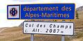 Signpost at the summit of the Col des Champs as of 2013
 -
 Signpost at the summit of the Col des Champs as of 2014


References
- ^ "Cayolle-Champs-Allos - Bikemap - Your bike routes online". bikemap.net. Archived from the original on 21 July 2015. Retrieved 22 August 2014.
- ^ "Col des Champs (2087 m)" (in German). www.quaeldich.de. Retrieved 22 August 2014.
- ^ "Col des Champs (2087 m)" (in German). www.quaeldich.de. Retrieved 22 August 2014.
- ^ Topographic map published by IGN Number 3540 OT, Scale 1:25 000.
External links
- Profile on cyclos-cyclotes.org
- Description on Quäldich.de (in German)
- Cycling up to the Col des Champs: data, profile, map, photos and description
This Provence-Alpes-Côte d'Azur geography article is a stub. You can help Wikipedia by adding missing information. |
Content Disclaimer
Informasi ini disarikan dari Wikipedia dan disajikan kembali untuk tujuan edukasi. Konten tersedia di bawah lisensi CC BY-SA 3.0. Kami tidak bertanggung jawab atas ketidakakuratan data yang bersumber dari kontribusi publik tersebut.
- The information displayed on this website is sourced in part or in whole from Wikipedia and has been adapted for the purpose of restating it. We strive to provide accurate and relevant information, however:
- There is no guarantee of absolute accuracy. Wikipedia is an open, collaborative project that can be edited by anyone, so information is subject to change.
- It is not intended to constitute professional advice. The content displayed is for informational and educational purposes only. For important decisions (e.g., medical, legal, or financial), please consult a professional.
- Content copyright. Wikipedia is licensed under the Creative Commons Attribution-ShareAlike License (CC BY-SA). This means that content may be reused with appropriate attribution and shared under a similar license.
- Responsible use. Any risk arising from the use of information from this website is entirely the responsibility of the user.