|
| Artikel atau sebagian dari artikel ini mungkin diterjemahkan dari Kidal (Mali) di en.wikipedia.org. Isinya masih belum akurat, karena bagian yang diterjemahkan masih perlu diperhalus dan disempurnakan. Jika Anda menguasai bahasa aslinya, harap pertimbangkan untuk menelusuri referensinya dan menyempurnakan terjemahan ini. Anda juga dapat ikut bergotong royong pada ProyekWiki Perbaikan Terjemahan.
(Pesan ini dapat dihapus jika terjemahan dirasa sudah cukup tepat. Lihat pula: panduan penerjemahan artikel) |
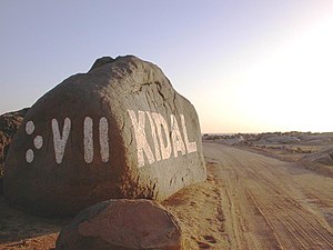
Kidal (bahasa Tifinagh: ⴾⴸⵍ) adalah kota kecil sekaligus commune di daerah gurun pasir Mali Utara. Kota ini terletak 285 km (177 mi) di sebelah timur laut kota Gao dan merupakan ibu kota Region Kidal. Luas region ini 9.910 km2 (3.830 sq mi) dan mencakup kota Kidal dan 31 penghunian lain[2]
Tanggal 30 Marchet 2012, Kidal dan pangkalan militernya diraih National Movement for the Liberation of Azawad as part of the Tuareg rebellion for the independence of Azawad. A spokesman for the Malian military junta said "To preserve the life of the people of Kidal, the military command decided not to prolong the battle".[3] Gao and Timbuktu were captured within the next 48 hours, and on 6 April, the National Movement for the Liberation of Azawad declared the independence of Azawad from Mali.[4][5] In the course of the conflict the MNLA lost their control to Islamist militias.[6] On 30th January 2013 French and Malian forces moved into the town to bring it back under government control.[7]
| Data iklim Kidal
|
| Bulan
|
Jan
|
Feb
|
Mar
|
Apr
|
Mei
|
Jun
|
Jul
|
Agt
|
Sep
|
Okt
|
Nov
|
Des
|
Tahun
|
| Rata-rata tertinggi °C (°F)
|
28.0
(82.4)
|
31.1
(88)
|
34.8
(94.6)
|
38.8
(101.8)
|
41.5
(106.7)
|
41.9
(107.4)
|
39.9
(103.8)
|
38.4
(101.1)
|
39.1
(102.4)
|
38.0
(100.4)
|
33.4
(92.1)
|
28.9
(84)
|
36.15
(97.06)
|
| Rata-rata terendah °C (°F)
|
12.5
(54.5)
|
14.8
(58.6)
|
18.7
(65.7)
|
23.0
(73.4)
|
27.0
(80.6)
|
28.6
(83.5)
|
27.2
(81)
|
26.2
(79.2)
|
26.0
(78.8)
|
23.2
(73.8)
|
18.0
(64.4)
|
13.7
(56.7)
|
21.58
(70.85)
|
| Presipitasi mm (inci)
|
0.6
(0.024)
|
0.1
(0.004)
|
0.2
(0.008)
|
1.0
(0.039)
|
5.3
(0.209)
|
11.6
(0.457)
|
36.8
(1.449)
|
45.9
(1.807)
|
23.1
(0.909)
|
3.0
(0.118)
|
0.2
(0.008)
|
0.2
(0.008)
|
128
(5.04)
|
| Sumber: World Weather Information Service[8]
|
Templat:Contains Tifinagh text
Catatan
- ^ Resultats Provisoires RGPH 2009 (Région de Kidal) (PDF), République de Mali: Institut National de la Statistique, diarsipkan dari versi asli (PDF) tanggal 2011-07-22, diakses tanggal 2013-08-15
- ^ Communes de la Région de Kidal (PDF) (dalam bahasa French), Ministère de l’administration territoriale et des collectivités locales, République du Mali, diarsipkan dari versi asli (PDF) tanggal 2012-03-09, diakses tanggal 2013-08-15 .
- ^ Mali coup: Rebels seize desert capital Kidal, BBC News, 30 March 2012, diakses tanggal 30 March 2012 .
- ^ Tuareg rebels declare the independence of Azawad, north of Mali, Al Arabiya, 6 April 2012, diakses tanggal 6 April 2012 .
- ^ Déclaration D’Indépendance De L'Azawad (dalam bahasa French), Mnlamov.net, 6 April 2012, diarsipkan dari versi asli tanggal 2012-10-18, diakses tanggal 28 January 2013 .
- ^ Morgan, Andy (23 October 2012), "Mali: no rhythm or reason as militants declare war on music", The Guardian, diakses tanggal 30 January 2013 .
- ^ Mali conflict: French 'enter last rebel town of Kidal', BBC, 30 January 2013, diakses tanggal 30 January 2013 .
- ^ Weather Information for Kidal, World Weather Information Service, Monthly averages over the 51 year period 1950-2000, diakses tanggal 2 July 2012
Pranala luar
Templat:Communes of the Kidal Region
|
